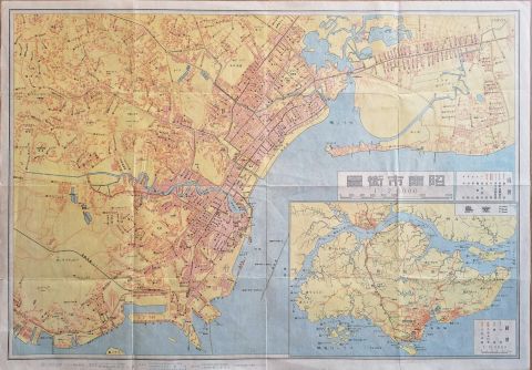
Singapore Syonan-to City Map
Rare 1942 Japanese occupation map of Singapore, historically known as Syonan-to. Printed during WW2
Inquire
Singapore Town
Rare spanish language map of Singapore town, highlighting the points of interest. Published in Madrid Espasa Calpe
Inquire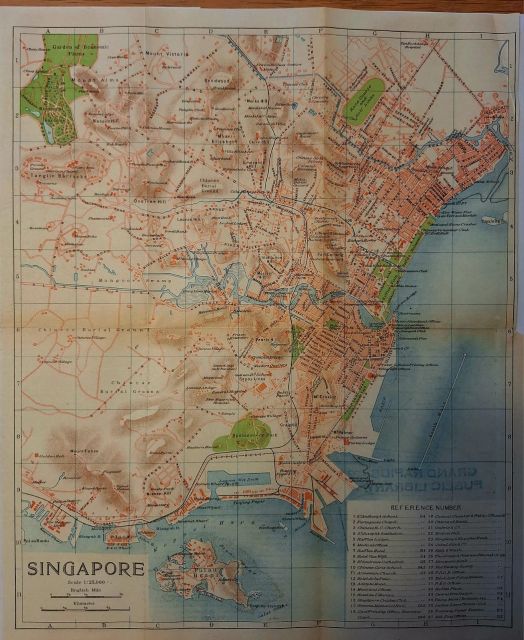
Singapore - town map
Rare beautifully detailed and attractive map of Singapore town in 1915. Published by the Imperial Japanese Railways
Inquire
1954 Colony of Singapore
Stunning detailed map of the Colony of Singapore in 1954 published by the Survey Dept. Federation of Malaya
Inquire
British Malaya and Singapore
Large map (with Japanese header) showing Malaya, Singapore and British North Borneo
Inquire
Singapore island
Mid 1950s elevation map of Singapore island with Singapore town (incl city limits), railroad, water pipeline and named villages.
Inquire![[sold] l'Ile de Sumatra (early map of Singapore)](https://cdn.prod.website-files.com/67026f719cd0171905f5a821/67fb57651009eed5413b6fa6_TN-20250413-WA0015.jpg)
[sold] l'Ile de Sumatra (early map of Singapore)
Exceptional and rare map by Pieter van der AA (only 100 were known to be published!) showing important trade centers along the Strait of Malacaca and Singapore
Inquire
Singapore - Keppel Harbour
Spectacular nautical map of Keppel Harbour and Singapore roads. Showing ports, harbours, Sentosa island etc.
Inquire
Escape map of Singapore and surroundings
Fabric ('escape') map of Singapore. Maps like this were given to soldiers due to their durability. Restricted and not for public use. GSGS
Inquire![[sold] Singapore Island (新加坡岛)](https://cdn.prod.website-files.com/67026f719cd0171905f5a821/67cd446baebf7cd83189f1d0_TN-SingaporeIsland.jpg)
[sold] Singapore Island (新加坡岛)
Published in the Malay Federation for the Chinese schools in Singapore
Inquire
Singapore - Soviet Map
Topographic Soviet military map of Singapore and surroundings
Inquire![[sold] Carte de l'Isle de Sumatra with Singapore](https://cdn.prod.website-files.com/67026f719cd0171905f5a821/67c4246172a814fbe28ef0d2_TN-20250302-WA0053.jpg)
[sold] Carte de l'Isle de Sumatra with Singapore
Famous mid 18th century copper engraved map of Singapore, Malay peninsula and surrounding islands. By Nicolas Bellin, published in Paris
Inquire


Singapore Town - Street Map
This city map of Singapore town was published in the 14th edition of Brockhaus’ Konversations Lexikon.
Inquire
![[sold] Singapore - Town and Island](https://cdn.prod.website-files.com/67026f719cd0171905f5a821/67c00f1b1e9d19226f075996_TN-20250227-WA0037.jpg)


![[Sold] Estrecho de Singapoore](https://cdn.prod.website-files.com/67026f719cd0171905f5a821/67c00b7b7680a0f5d1533bc4_TN-20250227-WA0029.jpg)


Singapore Stubborn Bastion in the East
Impressive war-time 1941 map of Singapore Island claiming its ability to withstand a potential Japanese invasion.
Inquire![[sold] Singapore Island](https://cdn.prod.website-files.com/67026f719cd0171905f5a821/6702706e0ecec56203d3ec90_tn_Singapore_Map_1959%20(1).jpg)
[sold] Singapore Island
1959 road map of Singapore island. Published in the USA for the Standard-Vacuum Oil Company
Inquire.jpg)
Singapore Town - Street Map
This city map of Singapore town was published in Leipzig as part of Brockhaus’ Konversations Lexikon.
Inquire