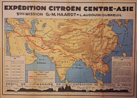
The Yellow Cruise (Croisière jaune) - Citroen
The Yellow Expedition ran from April 1931 to April 1932, it was an epic 12,000-kilomter automobiile journey across Asia, famously sponsored by French carmaker Andre Citroen
Inquire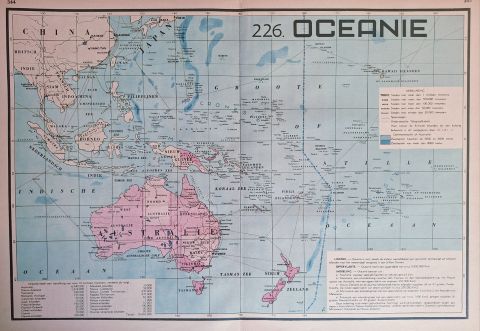
Oceanie
Vintage map of Oceania, produced in the 1930s ncluding an extensive legend for map symbols and territorial indicators.
Inquire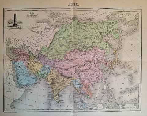
Asie
French map of Asia published by J. Migeon and produced by Alexandre Veuilllemin. The Procelain Tower in Nanjing feature on the left hand side top. Hand colored and steel engraved.
Inquire![[sold] Asie](https://cdn.prod.website-files.com/67026f719cd0171905f5a821/69ec8ddd7481da7b5d55459b_TN_1.jpg)
[sold] Asie
Highly decorative map of Asia by Victor Levasseur. This map was the centerpiece of his famous Atlas National Illustre, one of the last 19th century decorative atlases
Inquire![[sold] Colton's map of Asia](https://cdn.prod.website-files.com/67026f719cd0171905f5a821/696c87ff76d7f61b1387ceb1_TN_3_.jpg)
[sold] Colton's map of Asia
1885 Colton map of Asia. Colton's maps are acclaimed and showcase his unique style of famously detailed 19th-century cartography
Inquire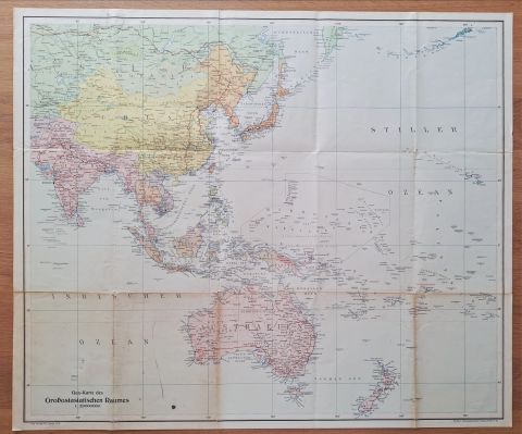
Gea Karte des Grossostasiatischen Raum
Large and colorful wartime map of Asia proper. Lots of detail to explore!
Inquire![[sold] Johnston's Asia with Singapore](https://cdn.prod.website-files.com/67026f719cd0171905f5a821/696c84e449758823a382e848_TN_4.jpg)
[sold] Johnston's Asia with Singapore
Johnston's colorful late 19th century map of Asia, featuring detailed map of Singapore island in inset
Inquire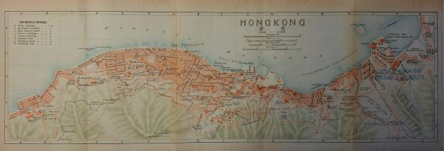
Hong Kong - Victoria Island
Rare. Published by the Imperial Japanese Railways. Detailed street map of Hong Kong in 1915. Lots of detail!
Inquire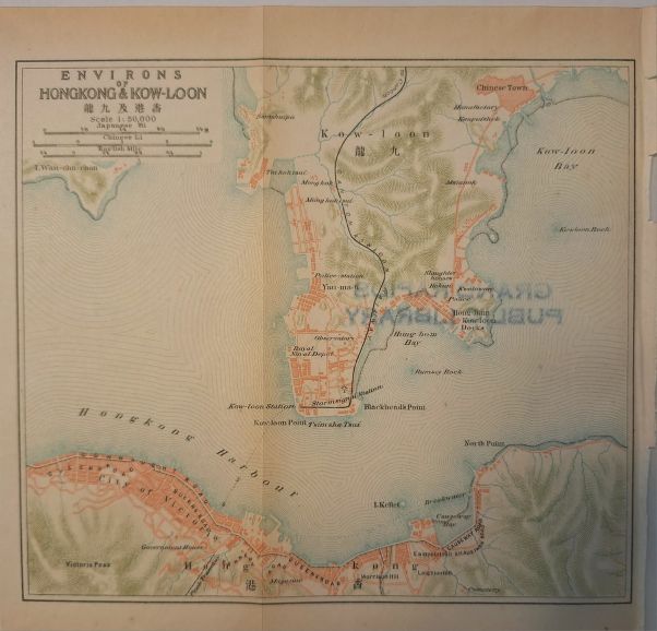
Environs of Hong Kong & Kow-Loon
Rare. Published by the Imperial Japanese Railways, detailed street map of Hong Kong and Kowloon
Inquire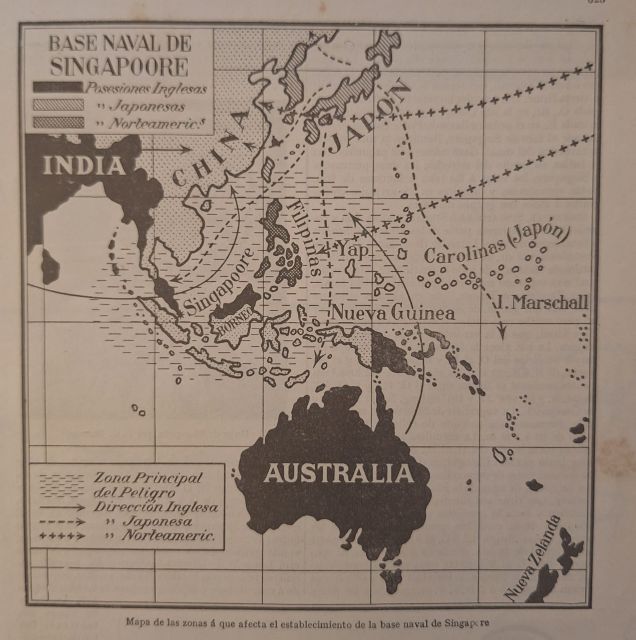
Naval Base of Singapore - Pacific Region
Pre-WW2 map of the area around the naval base of Singapore, depicting the primary high risk maritime zone
Inquire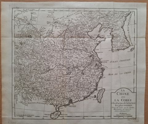
Map of China and Korea
Antique map of China and Korea, Adapted from a map by d'Anville, based on studies by Missionaries between 1708 and 1717
Inquire
Imperii Sinarum - Johannes Blaeu
Impressive map of China, Japan, and Korea. This is one of the most important maps of China in the 17th century!
Inquire
Malabar and Coromandel Coast - Southern India
Collectible map of southern India showing fortifications, strongholds and royal / colonial possessions in the early 18th century
Inquire![[sold] Asia drawn from the latest Astronomical Observations](https://cdn.prod.website-files.com/67026f719cd0171905f5a821/68366c0afb1d582d98c5fc09_TN-20250528-WA0114.jpg)
[sold] Asia drawn from the latest Astronomical Observations
Wilkinson's Asia. Dated Oct 24, 1808, published in London
Inquire

L'Indoustan comprenant la Presqu'isle de l'Inde
Map of indian subconntinet from Bombay to Ceylan intended to show the history of past voyages.
Inquire![[sold] Oestliche Halbkugel (eastern hemisphere)](https://cdn.prod.website-files.com/67026f719cd0171905f5a821/67fb5da44b3d53bc6ba58258_TN-20250413-WA0010.jpg)
[sold] Oestliche Halbkugel (eastern hemisphere)
Unusual map of Asia, dated 1832. By Stulpnagel / Ausfeld. Nice bright colors and decorative header.
Inquire
Carte du Golphe de Bengale
Striking map with beautiful compass rose in the center, showing detailed coastlines and trading towns. Published by the order of Mgr Le Compte De Maurepas, done by Nicolas Bellin / Schley
Inquire
l'Inde en deca du Gange
Map showing the lower part of India and Ceylon. The Indian Ocean trade winds are depicted and their seasons. By Rigobert Bonne
Inquire

![[sold] Asia](https://cdn.prod.website-files.com/67026f719cd0171905f5a821/67fb51d49a73c9d1d3163bc4_TN-20250413-WA0024.jpg)
[sold] Asia
Johnston's map Asia. Showing all territories in remarkable detail, possessions, submarine cables, etc
Inquire
China and the Birman Empire
Qing dynasty, early 19th century China. Published under the supervision of the Society for Diffusion of Public Knowledge
Inquire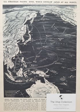
U.S. Strategic Pacific Sites which envelop Japan at all points
Map showing US, British and Japanese bases, stressing American naval communication from its base Pearl Harbour in Hawaii. G.F. Morrell
Inquire
Southern India & Ceylon
Map showing British territoties, feudatory and protected states. Hill tribes are colored yellow. Insets of Madras and Colombo
Inquire
Insula Ceilon olim Taprobana - Covens & Morties
Striking large copper engraved map of Ceylon (Sri Lanka), including part of South East India.
Inquire
Malabar and Coromandel - Homann Heirs
Rare and hand colored map titled 'Peninsula Indiae citra Gangem, hoc est Orae Celeberrimae Malabar & Coromandel. Cum adjacente Insula non minus celebratissima Ceylon (..).'
Inquire
Tartariae sive magni chami regno - Abraham Ortelius
Exceptional old color example of Abraham Ortelius' map of Tartary
Inquire
Asia ex magna orbis terre - Gerard Mercator
Mercator's famous map of Asia, in old color, showing the continent in detail and offering a fascinating cartographic snapshot of late-sixteenth century geographic thought.
Inquire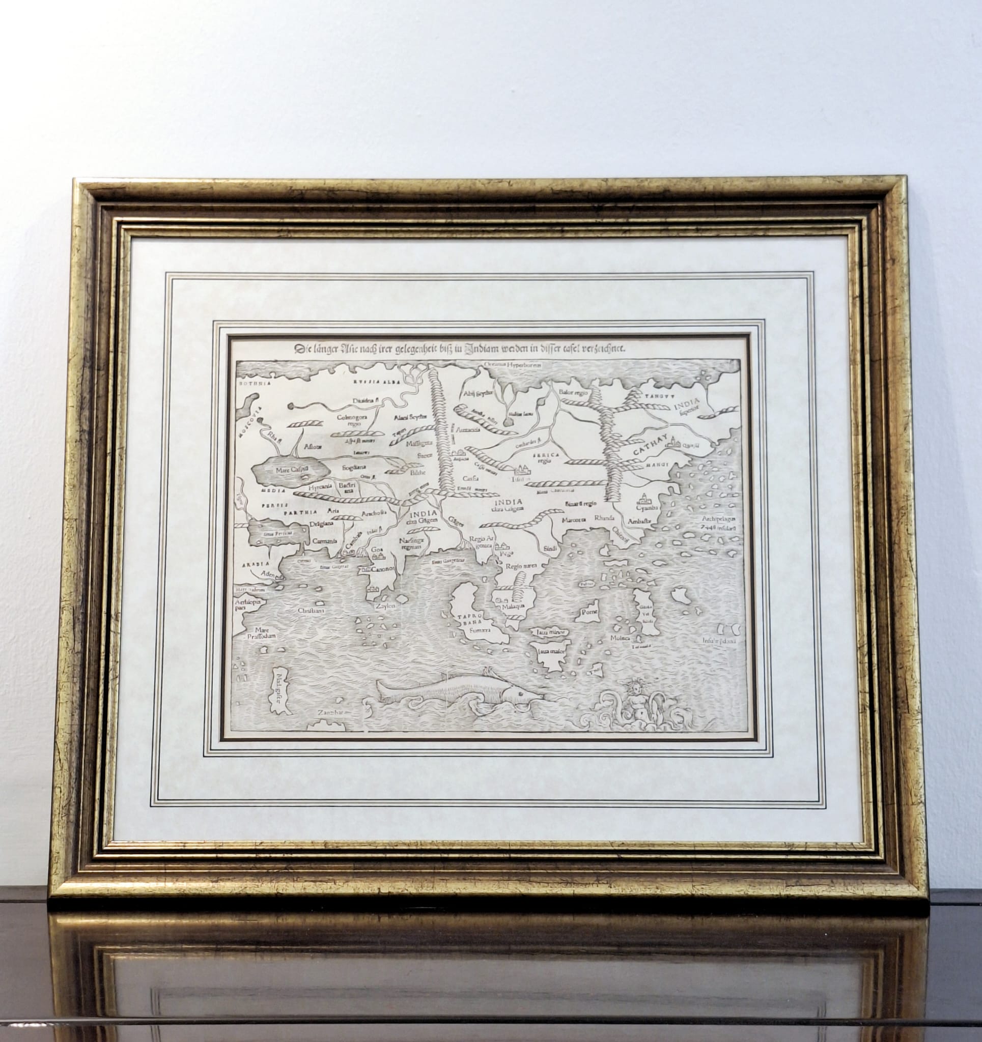
India Extrema XIX Nova Tabula - Munster
The first printed map of the Asia (!). Southeast Asia is largely unrecognizeable, although Java Minor and Major, Porne (Borneo), Moluca and several other islands are named.
Inquire
Japan - Pieter van der Aa
This intriguing hand-colored authentic antique map by Dutch cartographer Pieter van der Aa.
Inquire![[sold] Asiae Nova Descriptio - Jodocus Hondius](https://cdn.prod.website-files.com/67026f719cd0171905f5a821/67d6a16b9a3768e0b8999360_2.jpg)
[sold] Asiae Nova Descriptio - Jodocus Hondius
Fine example of Jodocus Hondius' updated and improved map of Asia, which first appeared in the 1606 edition of the Mercator Hondius Atlas
Inquire


![[sold] Asia - Turner](https://cdn.prod.website-files.com/67026f719cd0171905f5a821/67c3d22e57dee51195514330_TN-20250227-WA0066.jpg)


