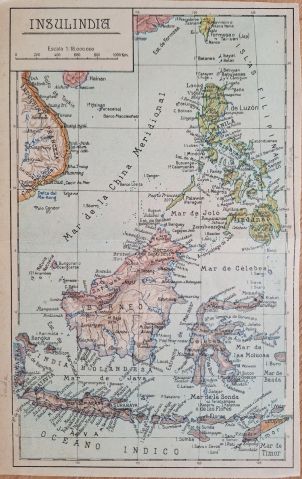
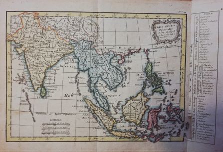
Les Indes Orientales et leur Archipel
Beautiful map op Southeast Asia after work from Bonne and Rizzi Zannoni. Published in Atlas Moderne by Lattré in 1795.
Inquire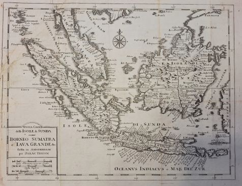
Sunda Islands - Isaac Tirion
Isaac Tirion’s 1740 masterpiece - stunningly detailed, copper engraved map of Malaysia, Borneo, Java.
Inquire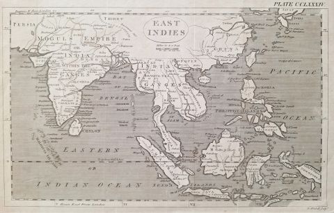
East Indies
Distinct and attractive map of the East Indies by Thomas Bowen. This map was part of the late 18th century edition of the Encyclopaedia Britannica.
Inquire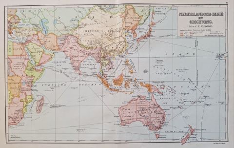
Nederlandsch Indie en Omgeving
Vintage colorful map of the Dutch East Indies, covering the South East Asia area from India to New Zealand. The map displays geopolitical boundaries, shipping routes and geographical features.
Inquire
Borneo Insula
Attractive and antique map of Borneo, copperplate engraving published around 1602 by Theodore de Bry
Inquire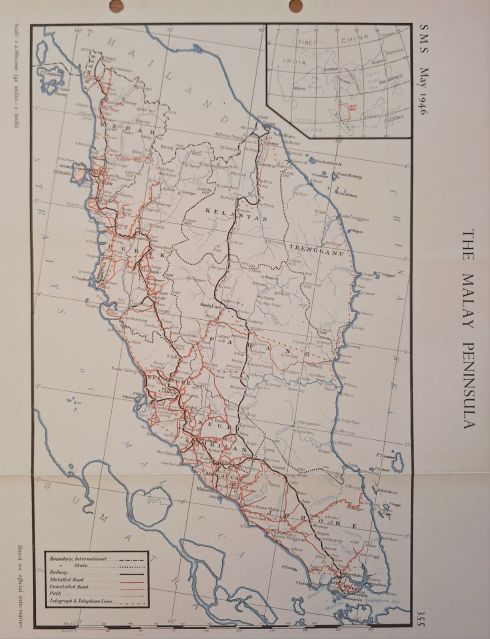
The Malay Peninsula
Survey map of Malaysia from 1946 showing metalled road, railways, telegraph lines etc. Shows Singapore island
Inquire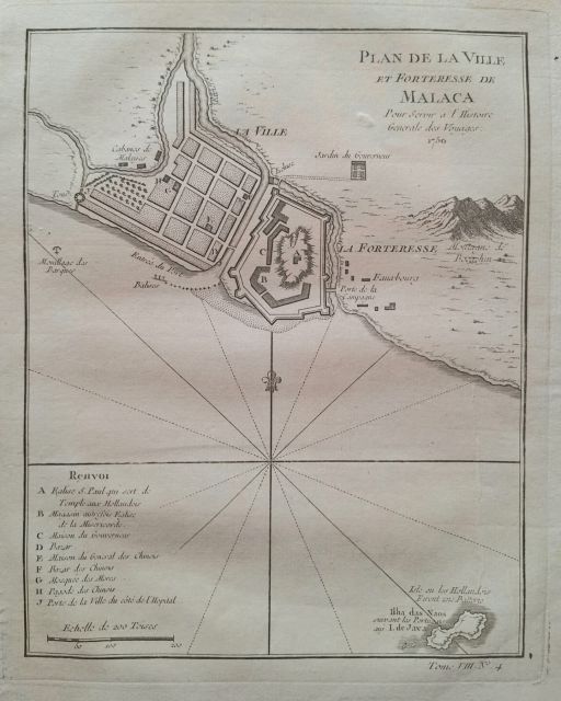
Plan of the city of Malacca
City plan of Malacca detailing the city and fortifications, as well as the Dutch church and Chinese bazaar.
Inquire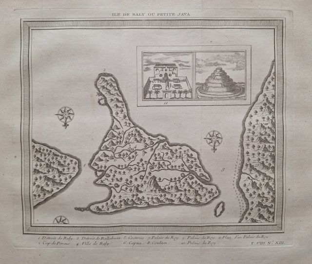
Map of Bali - or Little Java
Lovely map of Bali published in Paris by Jacques Nicolas Bellin
Inquire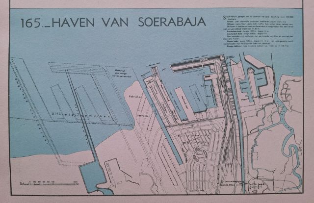
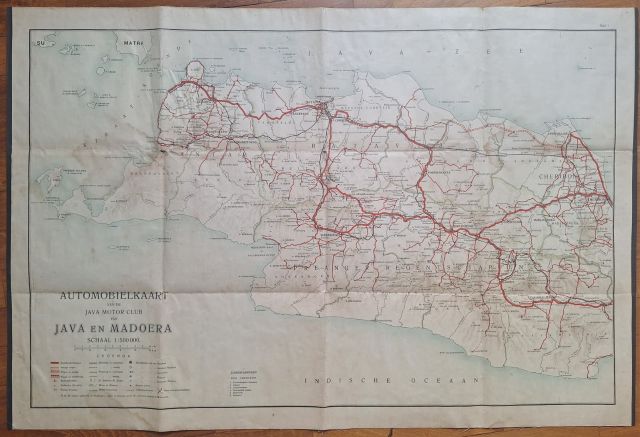
Automobile Map of Java and Madura
Vintage automobile map published by the Java Motor Club
Inquire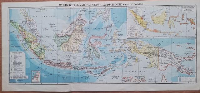
Netherlands East Indies - General Map
Detailed and colorful map of Indonesian islands and Singapore. Showing air connections, mail boat connections, timezones etc
Inquire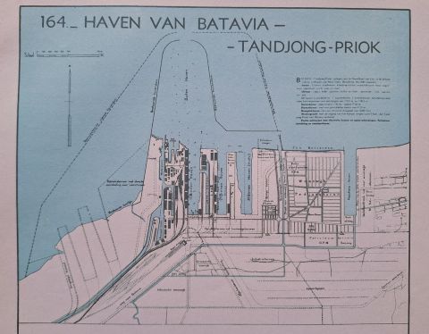
Port of Tanjung Priok Jakarta
Detailed map of maritime port of Tanjung Priok Jakarta (Batavia)
Inquire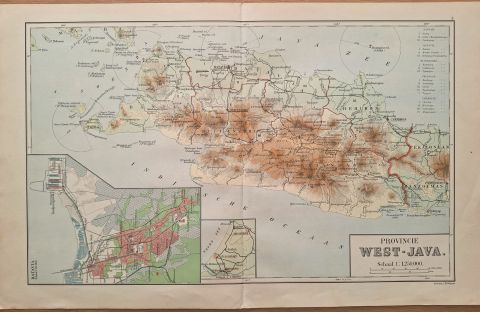
West Java and Jakarta
Attractive geographic map of West Java with a city map of Jakarta in the inset.
Inquire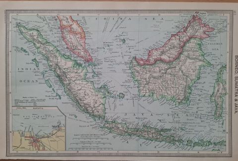
Map of Java, Borneo and Sumatra, Singapore
Detailed map of Singapore, Jakarta and surroundings. The map depitcs steamship connections and British, Dutch possesions, detailed map of Batavia in inset
Inquire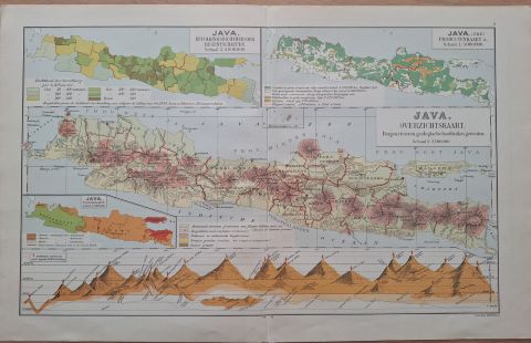
Geographic and Demographic map of Java
Colorful map of Java showing geography, population density, land use, and elevations
Inquire
Burma and Siam with Cochin China, Annam and Tong King
Late 19th century lithograph showing Thailand, Myanmar, Vietnam and Malaysia (incl Singapore)
Inquire
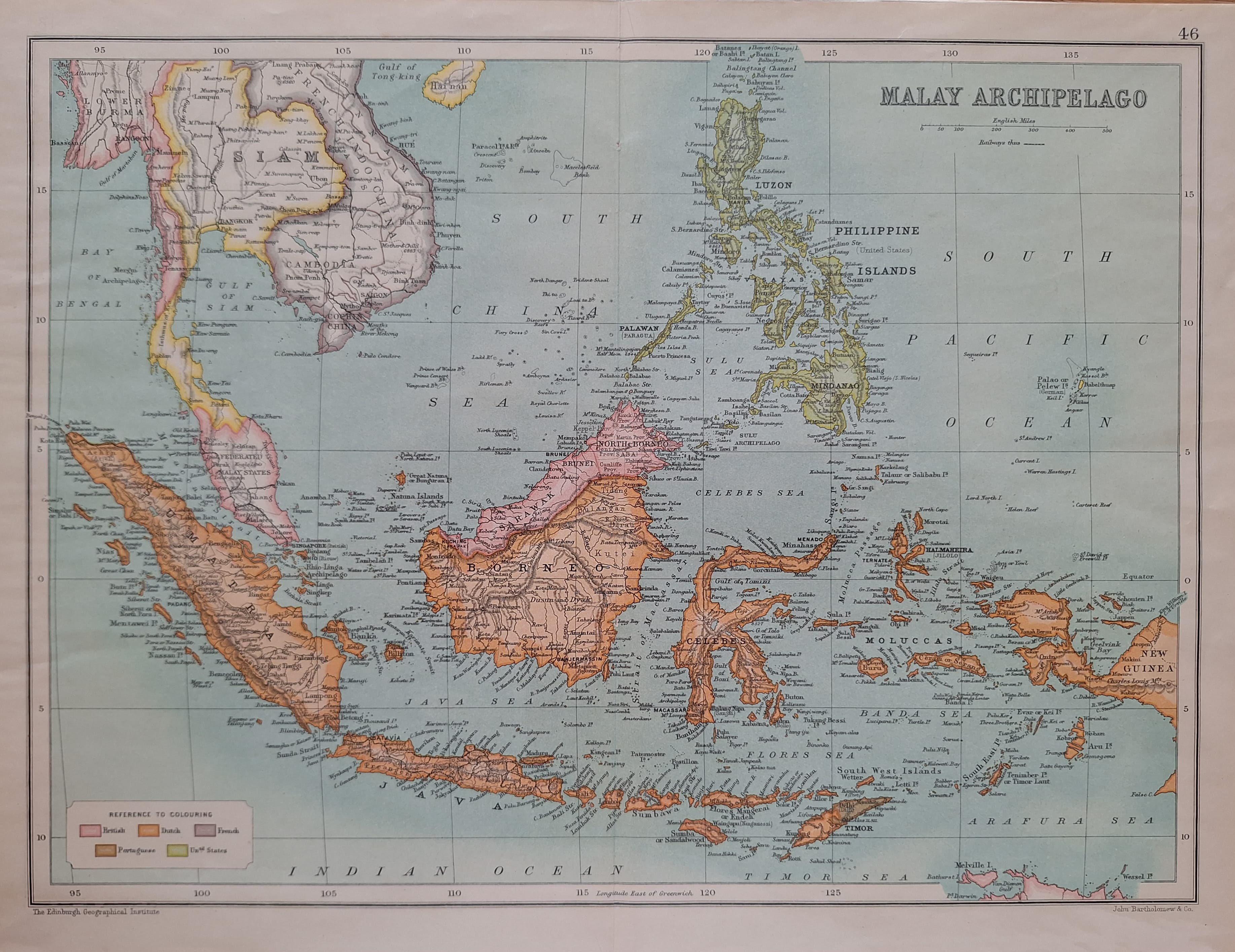
The Eastern or Malay Archipelago
Early lithograph of Singapore, British North Borneo and the Duch East Indies.
Inquire![[sold] The Malay Archipelago and South Eastern Asia](https://cdn.prod.website-files.com/67026f719cd0171905f5a821/6843b9237f140229633644ab_TN-20250607-WA002.jpg)
[sold] The Malay Archipelago and South Eastern Asia
Early lithographed attractive map of South East Asia, with colors depicting foreign colonial possessions
Inquire
Indo-China (Siam & French Indo-China)
Indochina and Malay States, beautifully colored map of Cambodia, Thailand, Vietnam
Inquire
East Indian Archipelago
Showing Singapore, South East Asia, Philippines and the East Indies Archipelago. Published in London
Inquire![[sold] Colton's East Indies](https://cdn.prod.website-files.com/67026f719cd0171905f5a821/68366917fa97f18587db825b_TN-20250528-WA0116.jpg)
[sold] Colton's East Indies
Stunning map of South East Asia. First American made map featuring Singapore island (inset)
Inquire
Farther India and Sunda Isles
Early lithographed map of South East Asia, Singapore and west Indonesia. Published by Tunison.
Inquire
Chart of the East India Islands
Drawn "under the direction of Arrowsmith and published as the act directs on March 1, 1808" in London
Inquire
An Accurate Map of the East Indies
Showing political divisions and geograhic features 'from the latest improvements' Thomas Bowen, London
Inquire![[sold] Carte des Indes en deca et au dela du Gange](https://cdn.prod.website-files.com/67026f719cd0171905f5a821/67fb620e14c00065b281e100_TN-20250413-WA0004.jpg)
[sold] Carte des Indes en deca et au dela du Gange
Left part of Rigobert Bonne's map of South East Asia, published by permission of the French King
Inquire
Chart of the East India Islands
Drawn "under the direction of Arrowsmith and published as the act directs on March 1, 1808" in London
Inquire
Cochinchine, Cambodge, Annam & Tonkin
Fine hand colored steel engraving with Saigon street plan and coat of arms. Mekong river delta in inset.
Inquire
Byzondere Kaart van het Eyland Amboina (Ambon)
Carte Particuliere de l'Isle d'Amboine. Published by Van der Schley, after Nicolas Bellin. Hand colored.
Inquire![[sold] South-Eastern Asia and the Malay Archipelago](https://cdn.prod.website-files.com/67026f719cd0171905f5a821/67fb5bdc286c19f6c048a92d_TN-20250413-WA0012.jpg)
[sold] South-Eastern Asia and the Malay Archipelago
Map of East and South East Asia with Hong Kong, Tokyo, Shanghai and the Moluccas in insets. George Philip, London
Inquire![[sold] A new map of the East India Isles](https://cdn.prod.website-files.com/67026f719cd0171905f5a821/67fb568e0b5d451d70534b35_TN-20250413-WA0016.jpg)
[sold] A new map of the East India Isles
Solid early 19th century map "from the latest discoveries". Engraved by John Cary, dated 21 Dec 1801. Strand London.
Inquire
East India Islands
Drawn by Aaron Arrowsmith and published by Constable & Co. Edinburgh. This map is part of the Beagle Library Project.
Inquire
Scheepvaartverbindingen - Koninklijke Pakketvaart Maatschappij
Shipping routes of the Dutch KPM. Established in 1888, KPM played a pivotal role in connecting the islands of the archipelago until 1967.
Inquire
Malay States and Singapore
Large US Government WW2 era terrain map published by Eductation and Information Service
Inquire
Asiatic Archipelago
Colorful map published by the Society for Diffusion of Useful Knowledge, Edward Stanford London
Inquire
Malaya Sumatra Java Borneo
Times Atlas map of Singapore and Malaya. John Bartholomew, Geographical Institute Edinburgh
Inquire
The Indian Archipelago.
Steel engraving published by Edward Weller and Blackie & Son in Edinburgh / London. Singapore highlighted in red
Inquire![[sold] New Map of India and China](https://cdn.prod.website-files.com/67026f719cd0171905f5a821/67fb4b589128520549379cf3_TN-20250413-WA0034.jpg)
[sold] New Map of India and China
Striking map of Southeast Asia from England's foremost mapmaker of the eighteenth century, John Senex
Inquire
The Indian Archipelago
Nicely engraved map with remarkable detail, with Singapore outlined in red. Blackie & Son, Glasgow
Inquire
The Malay Peninsula (w/ Singapore island)
Early 20th century Singapore island and Malay Peninsula. By George Philip, London
Inquire
Indochine Physique
1930s map of French Indochina and other parts of South East Asia, incl Singapour. Maurice Allain, Paris
Inquire
A Chart of the East India Islands
Old map of the East Indies by Peter Jackson, London & Paris
Inquire
Oriental Islands
Rare and fine map of Philippines, Bornea and parts of Indonesia, including the Spice Islands. Grattan & Gilbert, London
Inquire
East Indies
Fine colored map of South East Asia showing territories and foreign possessions
Inquire
Saigon
Showing Saigon and environs in the Mekong river delta. Elisee Reclus, Paris / London
Inquire
The East Indies & Indo-China: Industries & Communications
Showing the principal through routes by land and sea, including steamship lines. Names of the principal products (cacao, rubber, etc) are printed in red
Inquire![[sold] Malay or East Indian Archipelago with Burma & Siam](https://cdn.prod.website-files.com/67026f719cd0171905f5a821/67fb4141ae7be5ea4640ea20_TN-20250413-WA0048.jpg)
[sold] Malay or East Indian Archipelago with Burma & Siam
Attractive map showing foreign possessions, submarine cables and steamship lines. Printed in London by George Philip, the London Geographical Institute
Inquire
Batavia - Homann Heirs
Attractive and much sough-after mid-18th century large map of Batavia
Inquire
Insulae Indiae Orientalis - Jodocus Hondius
This impressive map reflects the increasing Dutch interest in South East Asia in the wake of the establishment of the Dutch East India Company.
Inquire
Sumatra / Tramontana - Giovanni Battista Ramusio
Giovanni Ramusio was the son of Paolo Ramusio, a magistrate of the Venetian city-state.
Inquire
Isles Philippines - Homann Heirs
Very large showpiece sea chart of the Philippines issued by Homann Heirs.
Inquire

Burma, Siam, French Indo-China and Straits Settlements
By Dodd, Mead & Co. Colorful and attractive map of South East Asia, with colors indicating foreign powers.
Inquire
Batavia - Japanese Government Railways
Batavia antique town plan. City of Jakarta. Indonesia 1917.
Inquire
East India Islands - Bacon
..with parts of Burma, Siam and Annam. Turn of the 20th century map with inset of Singapore and Jakarta (Batavia).
Inquire![[sold] The Islands of the East Indies - WIlkinson](https://cdn.prod.website-files.com/67026f719cd0171905f5a821/67c425468286b7a4d9dd6c01_TN-20250302-WA0099.jpg)
![[sold] Burma and Farther India (with Singapore)](https://cdn.prod.website-files.com/67026f719cd0171905f5a821/67c424be7145f148206db2e6_TN-20250302-WA0028.jpg)
![[sold] Carte des Isles de Java Sumatra Borneo &a par N Bellin](https://cdn.prod.website-files.com/67026f719cd0171905f5a821/67c424083ac97fdfe9f6a2de_TN-20250302-WA0049.jpg)

Malay Peninsula &c
19th century steel engraved map that was published in Blackie's Modern Atlas.
Inquire![[sold] Farther India (with Singapore)](https://cdn.prod.website-files.com/67026f719cd0171905f5a821/67c4232724388016e29f0691_TN-20250302-WA0087.jpg)


![[sold] East India Islands - Khull](https://cdn.prod.website-files.com/67026f719cd0171905f5a821/67c41c15cfab32765236c22b_TN-20250302-WA0075.jpg)


Nederlandsch-Indischen Archipel
This rare "Overzichtskaart van den Nederlandsch-Indischen Archipel" is probably one of the most attractive maps of the region that I know of. This map was published in 1928 by the National Topographic Service in Weltrevreden - the historic 19th-century colonial district of Batavia, modern-day Jakarta.
Inquire


![[sold] East India Islands](https://cdn.prod.website-files.com/67026f719cd0171905f5a821/67c3ebd03e85e706cbdd966c_TN-20250227-WA0012.jpg)


